
When flood rescue videos from Kansas City started spreading online this week, many homeowners felt the same reaction: Could that happen near me? Even people outside mapped flood zones began checking their addresses, insurance papers, and loan files. As a result, survey offices and engineering firms saw a sudden spike in calls about one document — the elevation certificate.
This shift happens often after high-profile flood events. First, the news shows dramatic rescues. Then, lenders, insurers, and buyers grow cautious. Soon after, property owners receive new questions about flood risk and building elevation. Therefore, if you own, sell, refinance, or develop property in the Kansas City area, this moment matters.
Flood News Changes Behavior Faster Than Flood Maps
Flood maps update slowly. However, public reaction moves fast.
When people watch rescue crews pull drivers from high water or evacuate homes, they stop thinking in map zones. Instead, they think in real streets and real buildings. Because of that, buyers start asking sellers about flood risk. Meanwhile, lenders review files more closely. At the same time, insurance underwriters double-check elevation data.
Even if your property never took on water, nearby flooding can still trigger review questions. That’s why many owners hear about an elevation certificate right after a viral flood event — not before.
What Triggers the Sudden Documentation Requests
Most owners expect document requests during a sale or new construction. However, post-flood periods create a different pattern. The trigger comes from caution, not the process stage.
For example, lenders often reopen risk checks when regional flooding makes headlines. Likewise, insurers may flag renewals for closer review. In addition, buyers under contract sometimes add last-minute proof requests after seeing flood coverage.
So the building did not change — but the risk attention did.
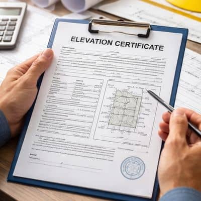
As a result, professionals start asking a simple question: “Do we have verified elevation data for this structure?”
That question leads straight to an elevation certificate.
Nearby Flooding Still Raises Questions
Many people assume only flooded properties face review. In reality, proximity matters too.
Drainage channels, creeks, and low corridors carry water fast during heavy storms. Therefore, underwriters often look at nearby flow paths, not just zone labels. If your neighborhood appears in flood footage, reviewers may request elevation proof even when your lot sits outside the deepest risk area.
This step does not mean your property failed. Instead, it means reviewers want measured data rather than assumptions. Clear numbers calm decisions. Guesswork slows them.
The 72-Hour Surge After Major Flood Coverage
Based on past storm cycles, documentation demand rises quickly within a few days of major flood news. The pattern looks like this:
First 24 hours: Public concern rises. Owners check maps and insurance papers.
Next 24 hours: Buyers and agents begin asking questions. Loan officers send clarification emails.
By 72 hours: Survey and engineering offices receive increased requests for elevation certificate checks.
Consequently, owners who act early avoid deadline pressure later. Those who wait often face rushed timelines tied to closings or renewals.
Real Situations KC Owners Face Right Now
This week’s calls follow familiar story lines.
Some owners plan to close a sale soon. However, the buyer saw flood rescue clips and now wants elevation proof before moving forward.
Others started a refinance last month. Now the lender adds an elevation document condition before final approval.
Meanwhile, landlords with renewing policies receive updated insurance questions tied to building elevation.
In each case, the property did not change. Still, the file review did. Therefore, the elevation certificate becomes the fastest way to answer concerns with measured facts.
How This Demand Differs From Normal Requests
Normal elevation certificate requests usually connect to permits, construction, or known flood zones. Post-flood demand works differently.
This surge comes from regional attention, not project stage. It often appears mid-process. For instance, a loan already in underwriting suddenly needs elevation verification. A buyer already under contract wants added proof. An insurer already quoting asks for confirmation.
So timing feels random — yet the cause follows a clear pattern: visible flood risk increases documentation caution.
The Most Common Mistake After Flood Headlines
Under stress, owners often order the wrong service. That mistake wastes time and money.
For example, some request a basic property survey when reviewers actually want elevation data. Others send outdated documents that no longer match current standards. Still others wait until a lender sets a hard deadline.
Instead, owners should confirm the exact document requested. When the question focuses on building height versus flood level, the needed document is an elevation certificate — not a boundary survey or site plan.
Clarity first saves delay later.
Quick Self-Check: Will Someone Ask You for Elevation Proof?
You can run a quick triage today.
You likely face a request soon if:
- You have an active refinance or loan review
- Your flood insurance renews within 90 days
- You plan to sell or buy property now
- Your area appeared in recent flood coverage
- An insurer asked follow-up risk questions
If two or more apply, prepare early. That step reduces closing stress and insurance delays.
Property Types Seeing the Fastest Spike
Recent request patterns show higher demand among certain property groups.
Homes near drainage routes lead the list. Next come light commercial buildings near water corridors. Multi-unit properties also see more review questions because insurers watch them closely. In addition, recently renovated structures often trigger elevation rechecks since reviewers reassess risk after improvements.
Therefore, if your property fits one of these groups, early elevation verification makes sense.
What Smart Owners Do Differently After Flood Events
Experienced owners treat flood news as a signal, not a scare.
First, they gather existing documents. Next, they confirm whether elevation data already exists. Then, they verify whether that data still meets current standards. If not, they order an updated elevation certificate before anyone sets a deadline.
Because of that approach, their transactions keep moving. Their insurance reviews move faster. Their buyers feel more confident.
Preparation beats panic every time.
Replace Fear With Measured Facts
Viral flood rescues create strong emotions. That reaction makes sense. However, property decisions work best with measured data, not headlines.
An elevation certificate does one simple but powerful thing: it replaces uncertainty with verified elevation numbers. Lenders understand it. Insurers trust it. Buyers respect it.
So if recent Kansas City flood coverage made you wonder about your property risk, take the practical next step. Check your elevation documentation status now. When questions come — and they often do after events like this — you will already have the answer ready.