How To Find Your Property On FEMA’s Flood Insurance Rate Maps

What are FEMA flood maps?
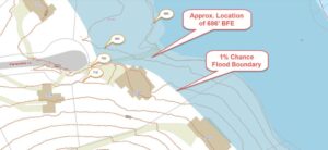
FEMA’s Flood Insurance Rate Maps (FIRMs) or just Flood Maps are provided after a flood risk assessment has been completed or updated for a community.  This study is known as a Flood Insurance Study.  The FIRM gives you the Base Flood Elevations (BFEs) and insurance risk zones in addition to floodplain boundaries.  The FIRM may also show a delineation of the regulatory floodway.

Once the “insurance risk zone”  (commonly referred to as the flood zone) is determined, actuarial rates, based on these risk zones, are then applied for newly constructed, substantially approved, and substantially damaged buildings.  FEMA uses these rates to determine the insurance rate you will pay for flood insurance

FEMA’s Digital Flood Maps

FEMA discontinued the production and distribution of paper flood maps in 2009 as part of its Digital Vision Initiative. This affected all the Flood Maps, boundary information, and study reports. However, clients can still view the products for free through their website or buy them in digital format.

To view these flood maps online, go to FEMA’s Map Service Center and key in your address (hi-lited area shown here) search for your home.  This will prompt you to then select the map that covers your area.  The Flood Maps are somewhat cumbersome to use online. It is best to go through the tutorial on the bottom right of the address search page for an easier and more effective use of the GIS map.


author avatar
Surveyor

More Posts

Two land surveyors using a total station on a construction site representing boundary survey delays in real estate
boundary surveying
Surveyor

Boundary Survey Delays Are Killing Real Estate Deals

If you’ve ever waited weeks for your home closing and felt like the surveyor disappeared, you’re not alone. Many buyers, sellers, and real estate agents are asking the same question: “What’s taking so long with the boundary survey?” A boundary survey might sound like a small step, but it can

Read More »
Land surveyor using a total station during an elevation survey to record precise land measurements for documentation
flood damage
Surveyor

Why Every Elevation Survey Should Be Documented

If you’ve ever had a fence, driveway, or flood insurance claim turn into a neighborhood argument, you know how fast things can escalate. That’s where an elevation survey becomes more than a technical report—it’s your best legal protection. In St. Louis, homeowners and builders often order elevation surveys for flood

Read More »
Aerial view of construction site showing trucks and heavy equipment preparing land development that requires an alta title survey
alta survey
Surveyor

Why Data Centers Need an ALTA Title Survey First

Kansas City is in the middle of a digital building boom. Just last month, Port KC approved billions in private funding for new data centers, and companies like DataBank have already started expanding their footprint in the metro. These massive projects power the internet, cloud storage, and the apps we

Read More »
Land surveyor using a total station and reviewing records for an ALTA Land Title Survey
alta survey
Surveyor

ALTA Land Title Survey Prep: MSD & County Records

When you order an ALTA Land Title Survey, you expect clear results that lenders, attorneys, and title companies can trust. Yet many surveys take longer than they should. The delays often come from missing local data—like sewer easements, parcel boundaries, or recording requirements. The good news? With the right prep,

Read More »
Aerial view of a neighborhood with houses and cleared lots highlighting property line survey disputes and urban development
boundary surveying
Surveyor

Property Line Survey Sparks Neighborhood Controversy

If you live in Kansas City or own property here, you’ve probably heard about the recent controversy in the Valentine neighborhood. At the heart of this debate is a simple but powerful tool called a property line survey. This survey defines where one property ends and another begins. But in

Read More »
Surveyor performing a boundary survey on residential property after ground movement
boundary surveying
Surveyor

Why Even a Small Quake Calls for a Boundary Survey

On September 5, 2025, a 2.4 magnitude earthquake shook near Fenton in South St. Louis County. Most residents didn’t even notice it. No broken windows, no major cracks, and certainly no chaos. Yet, even a minor event like this can shift things in ways that aren’t obvious. That’s where a

Read More »