How To Find Your Property On FEMA’s Flood Insurance Rate Maps

What are FEMA flood maps?
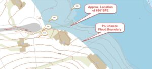
FEMA’s Flood Insurance Rate Maps (FIRMs) or just Flood Maps are provided after a flood risk assessment has been completed or updated for a community.  This study is known as a Flood Insurance Study.  The FIRM gives you the Base Flood Elevations (BFEs) and insurance risk zones in addition to floodplain boundaries.  The FIRM may also show a delineation of the regulatory floodway.

Once the “insurance risk zone”  (commonly referred to as the flood zone) is determined, actuarial rates, based on these risk zones, are then applied for newly constructed, substantially approved, and substantially damaged buildings.  FEMA uses these rates to determine the insurance rate you will pay for flood insurance

FEMA’s Digital Flood Maps

FEMA discontinued the production and distribution of paper flood maps in 2009 as part of its Digital Vision Initiative. This affected all the Flood Maps, boundary information, and study reports. However, clients can still view the products for free through their website or buy them in digital format.

To view these flood maps online, go to FEMA’s Map Service Center and key in your address (hi-lited area shown here) search for your home.  This will prompt you to then select the map that covers your area.  The Flood Maps are somewhat cumbersome to use online. It is best to go through the tutorial on the bottom right of the address search page for an easier and more effective use of the GIS map.

author avatar
Surveyor

More Posts

Vacant land with a wooden fence representing the need for a perc test before building
land surveying
Surveyor

Perc Test Essentials for Vacant Land Buyers

Buying vacant land feels exciting, doesn’t it? You picture building your dream home, setting up a cabin by the woods, or maybe holding on to the land as an investment. But before you rush into signing papers, there’s one thing you can’t afford to skip—the perc test. It’s not something

Read More »
Land surveyor using tripod equipment during a topographic survey in Kansas City subdivision site
land surveying
Surveyor

Topographic Survey as the First Step to Subdivision Planning

When you start a subdivision project, one thing comes before all others: the topographic survey. This survey maps out the land in detail, showing both natural and man-made features. Developers, engineers, and even city officials rely on it because it forms the blueprint for everything that comes next. Without this

Read More »
Wooden fence marking unclear property line in a grassy field
boundary surveying
Surveyor

Think That Fence Is the Property Line? Get a Boundary Survey

Owning property in Missouri can be simple—until you realize you’re not 100% sure where your land ends and your neighbor’s begins. Imagine thinking a fence marks your boundary for years, only to find out it’s actually on someone else’s land. That’s why a boundary survey is so important. It helps

Read More »
Professional surveyors using a total station to perform an ALTA survey on undeveloped property for a real estate transaction
alta survey
Surveyor

Why ALTA Surveys Matter in Property Transactions

An ALTA survey is a detailed map of a property that shows its boundaries, buildings, fences, roads, and other important features. It’s created by a professional land surveyor and follows strict standards set by the American Land Title Association (ALTA) and the National Society of Professional Surveyors (NSPS). This survey

Read More »
A drone hovers near the Scout statue overlooking downtown Kansas City, symbolizing the use of aerial LiDAR mapping in modern urban development.
land surveying
Surveyor

LiDAR Mapping: Changing How We Build Cities

In Kansas City, development is booming. New roads, buildings, and parks are changing the skyline—and behind many of these changes is a powerful tool called LiDAR mapping. It might sound like something from science fiction, but it’s very real and very useful. Let’s explore how LiDAR is helping Kansas City

Read More »

How to Read a Flood Elevation Certificate: A Homebuyer’s Guide

Buying a home in parts of Kansas means you may encounter a flood elevation certificate (EC) at some point. Instead of staring blankly at its numbers, here’s how to read and use it wisely—without repeating technical definitions. Why Homebuyers Should Pay Attention This form influences: ✅ Insurance rates: Lenders and

Read More »